O Dan y Dŵr - Hidden Seascapes of Wales
The "Tripods"
Formed by strong currents around the tip of the Llyn Peninsula
(zoom in for a closer look)
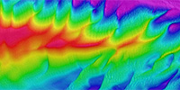
False colour projection of multibeam sonar data (where colours
represent different depths), illustrates the depth and physical
composition of an area 1500m x 800m of seabed located approximately two kilometres off the
northwest tip of the Llyn Peninsula covering part of an area known locally as the 'Tripods'.
This "West-up" image illustrates the west facing edge of a major sandbank that exists to the
north of the headland. The image illustrates an abrupt and almost linear boundary between
this sedimentary feature and the very different seabed type that exists to the west (in the upper
part of the image).
 (Northeastern end of the bank)
(Back to the main "Tripods" page)